Aletheia Kallos aletheiak@gmail.com [boundarypointpoint]
2016-05-25 08:46:55 UTC
tricountry the totally revised but still impartially coded official united
nations tripoint registry yearbook
*003 aeomsa* oman with saudi arabia & united arab emirates
[image: Inline image 1]
circa 2016
Loading Image...
by sarooj
example of aeom demarcation completed in 2009 using possibly same type of
pillar as at *aeomsa*
[image: Inline image 4]
circa 2016 http://www.panoramio.com/photo/20940982 by lars brodersen
example of omsa demarcation completed in 1995 using possibly same type of
pillar as at *aeomsa*
[image: Inline image 1]
circa 2012
http://mbfullemptyquarter.blogspot.com/2012/11/the-backside-border-expedition.html
by marina bruce
a careful try & guess culminating at 1995 omsa penultimate marker explained
below
multiple frontier of separation in remote area of arabian desert known
accordingly as the empty quarter
subject to conflicting claims since ancient times & contested militarily on
occasion by various surrounding states & nomadic tribes
narrowed & reduced to tricountry frontier *gbomsa* during saudi expansion
in 1930s
coalescing by 1949 into notional trijunction at or near buraimi oasis in
roughly n25d14m e55d46m claimed by all 3 parties
but displaced in 1955 following military struggle some 185km ssw to umm az
zamul with various transliterations & aka the awamir raiding well
most probably in around n22d42m30s2 e55d12m29s9 at approx elev100m asl
where reiterated & thus reinforced by 1956 gbom delimitations & surveys
reaching present political format *aeomsa *in 1971 upon independence of
united arab emirates
reiterated & reinforced there again by 1974 aesa accord
thus attaining full consensus regarding location for first time
tho the agreement accomplishing this was never actually ratified by uae &
has been disavowed by saudis
& while the general location has been repeatedly reconfirmed by aeom & omsa
agreements & demarcations since 1990
the precise position & configuration of the trijunction nevertheless remain
uncertain if not disputed
& the tripoint should thus be considered only tentatively demarcated at the
above stated location
because an alternative location at roughly n22d42m07s3 e55d12m44s9 has not
yet been positively eliminated
as tripartite confirmation of exact tripoint location was last reported to
be imminent in 2005 yet apparently still remains elusive today
while third marker pictured above appears to have been inserted into 1995
omsa demarcation at or just south of possible future boundary junction
point
if the present southernmost segment of aeom is simply projected further
south without deflection
best online mapping Loading Image...
also Loading Image...
[image: Inline image 2]
Loading Image...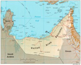
diagrammatic map of aeomsa possibilities
https://mail.google.com/mail/u/0/?ui=2&ik=22f10d286c&view=att&th=154e69e4d4afd160&attid=0.1&disp=safe&realattid=f_iomhumhi12&zw
diagrammatic map of omsa convergent to aeomsa
https://mail.google.com/mail/u/0/?ui=2&ik=22f10d286c&view=att&th=154e6a492b5e7274&attid=0.3&disp=safe&realattid=f_iomi2ptn14&zw
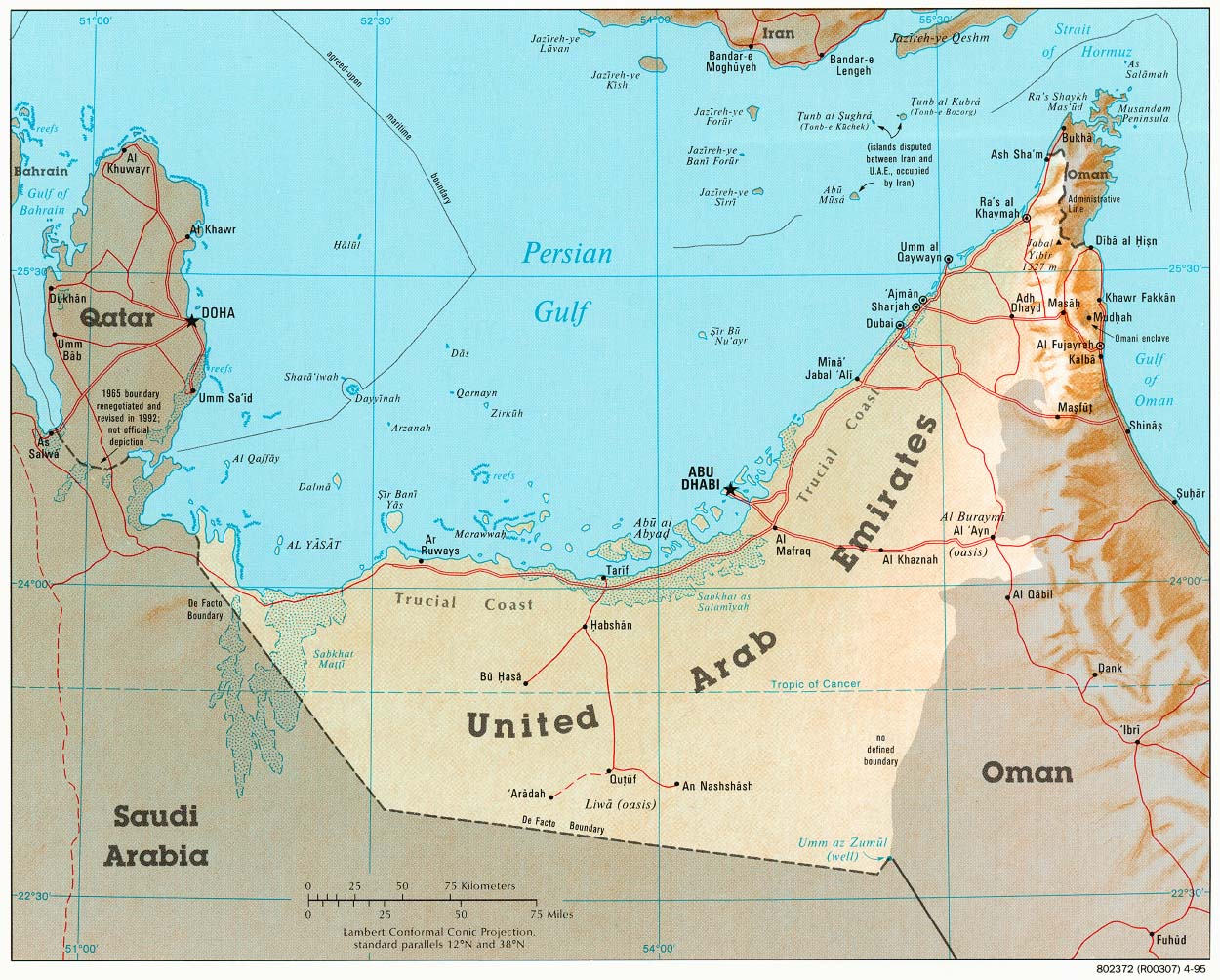
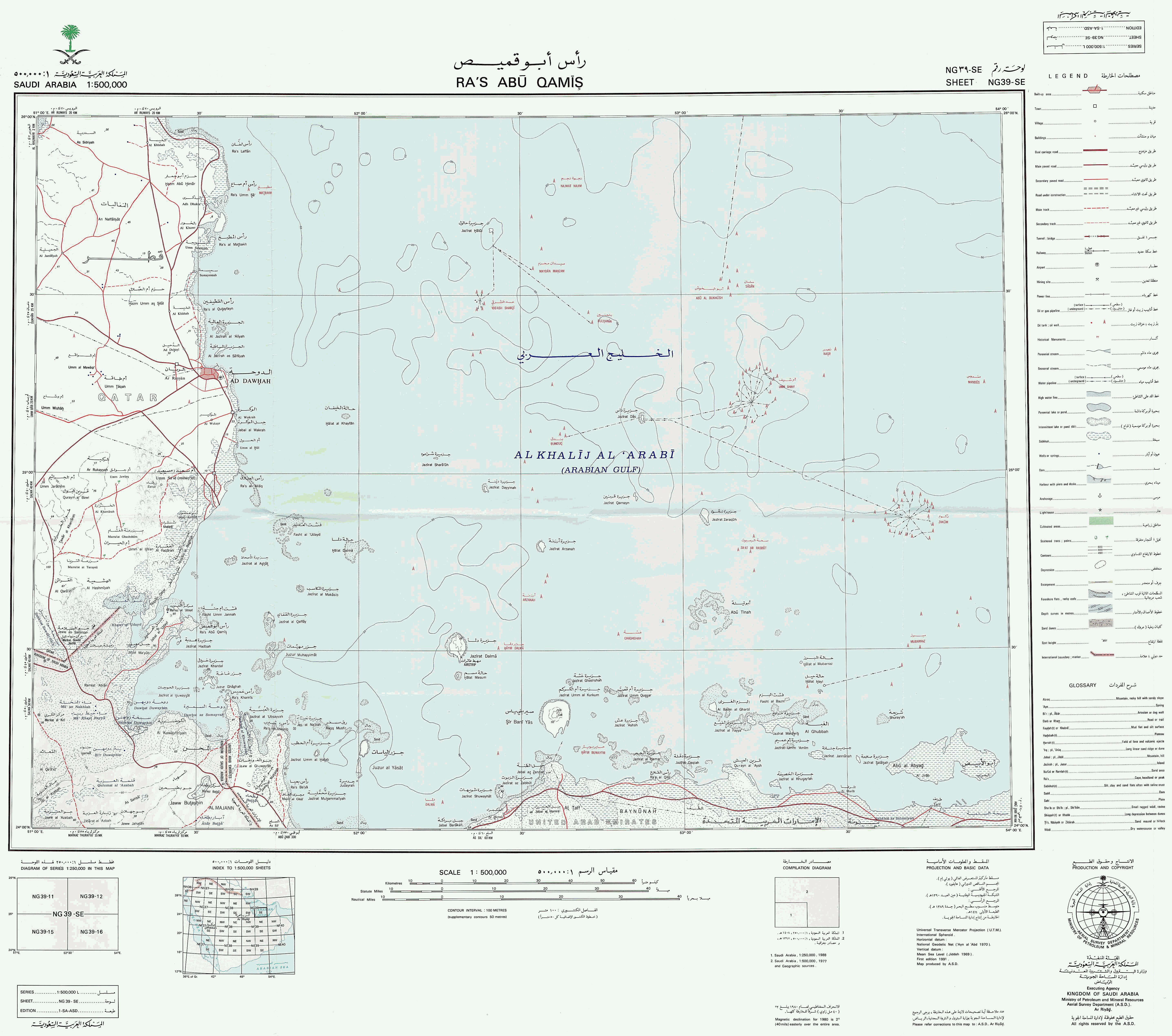
*004 aeqasa *qatar with saudi arabia & united arab emirates
[image: Inline image 3]
http://www.panoramio.com/photo/4423025
view facing east into persian gulf from niqyan in southeast qatar includes
hypothetical maritime territorial trijunction near mid horizon
as well as emirati makasib island just discernible at right horizon
while intervening seas & unseen coast beyond right edge of photo are
largely saudi notwithstanding emirati objection
hypothetical equidistance tricountry point in persian gulf
notional since independence of qatar and uae in 1971
& tho positionally elusive presumably situated at very roughly 24n40 51e35
based on de facto aesa land border disputed by uae
who prefer a tripoint position on dry land some 53km wsw at around 24n28
51e6 which was long maintained by british as *gbsa2aeqa *subdivisional
tripoint
but saudis agreed in 1974 to drop their claim to buraimi oasis for purposes
of settling *aeomsa* provided emirates dropped their claim to seacoast
southeast of qatar for purposes of settling *aeqasa*
so after several decades of saudi enforcement & effectivity in the
intervening area of some 2000 sq km the emirates appear to have little
recourse
best online mapping Loading Image...
also Loading Image...
1974 aesa treaty
https://treaties.un.org/doc/publication/unts/volume%201733/i-30250.pdf
diagrammatic map of above aeqasa guess
https://mail.google.com/mail/u/0/?ui=2&ik=22f10d286c&view=att&th=154e6a11e66775c1&attid=0.2&disp=safe&realattid=f_iomhysk813&zw
*nb* the present numbering sequence for tripoints 003 & 004 corrects for
their inadvertent alphabetical reversal in previous editions
nations tripoint registry yearbook
*003 aeomsa* oman with saudi arabia & united arab emirates
[image: Inline image 1]
circa 2016
Loading Image...
.jpg)
by sarooj
example of aeom demarcation completed in 2009 using possibly same type of
pillar as at *aeomsa*
[image: Inline image 4]
circa 2016 http://www.panoramio.com/photo/20940982 by lars brodersen
example of omsa demarcation completed in 1995 using possibly same type of
pillar as at *aeomsa*
[image: Inline image 1]
circa 2012
http://mbfullemptyquarter.blogspot.com/2012/11/the-backside-border-expedition.html
by marina bruce
a careful try & guess culminating at 1995 omsa penultimate marker explained
below
multiple frontier of separation in remote area of arabian desert known
accordingly as the empty quarter
subject to conflicting claims since ancient times & contested militarily on
occasion by various surrounding states & nomadic tribes
narrowed & reduced to tricountry frontier *gbomsa* during saudi expansion
in 1930s
coalescing by 1949 into notional trijunction at or near buraimi oasis in
roughly n25d14m e55d46m claimed by all 3 parties
but displaced in 1955 following military struggle some 185km ssw to umm az
zamul with various transliterations & aka the awamir raiding well
most probably in around n22d42m30s2 e55d12m29s9 at approx elev100m asl
where reiterated & thus reinforced by 1956 gbom delimitations & surveys
reaching present political format *aeomsa *in 1971 upon independence of
united arab emirates
reiterated & reinforced there again by 1974 aesa accord
thus attaining full consensus regarding location for first time
tho the agreement accomplishing this was never actually ratified by uae &
has been disavowed by saudis
& while the general location has been repeatedly reconfirmed by aeom & omsa
agreements & demarcations since 1990
the precise position & configuration of the trijunction nevertheless remain
uncertain if not disputed
& the tripoint should thus be considered only tentatively demarcated at the
above stated location
because an alternative location at roughly n22d42m07s3 e55d12m44s9 has not
yet been positively eliminated
as tripartite confirmation of exact tripoint location was last reported to
be imminent in 2005 yet apparently still remains elusive today
while third marker pictured above appears to have been inserted into 1995
omsa demarcation at or just south of possible future boundary junction
point
if the present southernmost segment of aeom is simply projected further
south without deflection
best online mapping Loading Image...
also Loading Image...
[image: Inline image 2]
Loading Image...
diagrammatic map of aeomsa possibilities
https://mail.google.com/mail/u/0/?ui=2&ik=22f10d286c&view=att&th=154e69e4d4afd160&attid=0.1&disp=safe&realattid=f_iomhumhi12&zw
diagrammatic map of omsa convergent to aeomsa
https://mail.google.com/mail/u/0/?ui=2&ik=22f10d286c&view=att&th=154e6a492b5e7274&attid=0.3&disp=safe&realattid=f_iomi2ptn14&zw
*004 aeqasa *qatar with saudi arabia & united arab emirates
[image: Inline image 3]
http://www.panoramio.com/photo/4423025
view facing east into persian gulf from niqyan in southeast qatar includes
hypothetical maritime territorial trijunction near mid horizon
as well as emirati makasib island just discernible at right horizon
while intervening seas & unseen coast beyond right edge of photo are
largely saudi notwithstanding emirati objection
hypothetical equidistance tricountry point in persian gulf
notional since independence of qatar and uae in 1971
& tho positionally elusive presumably situated at very roughly 24n40 51e35
based on de facto aesa land border disputed by uae
who prefer a tripoint position on dry land some 53km wsw at around 24n28
51e6 which was long maintained by british as *gbsa2aeqa *subdivisional
tripoint
but saudis agreed in 1974 to drop their claim to buraimi oasis for purposes
of settling *aeomsa* provided emirates dropped their claim to seacoast
southeast of qatar for purposes of settling *aeqasa*
so after several decades of saudi enforcement & effectivity in the
intervening area of some 2000 sq km the emirates appear to have little
recourse
best online mapping Loading Image...
also Loading Image...
1974 aesa treaty
https://treaties.un.org/doc/publication/unts/volume%201733/i-30250.pdf
diagrammatic map of above aeqasa guess
https://mail.google.com/mail/u/0/?ui=2&ik=22f10d286c&view=att&th=154e6a11e66775c1&attid=0.2&disp=safe&realattid=f_iomhysk813&zw
*nb* the present numbering sequence for tripoints 003 & 004 corrects for
their inadvertent alphabetical reversal in previous editions