Aletheia Kallos
2013-10-05 07:43:06 UTC
you may recall we have been trying to round all of these up since 2001
so the latest try here below represents quite a culmination
even if 6 of the 15 are wetpoints viewed at a considerable distance & 1 of
the 9 purported markers is questionable
1 bbmvni in elbe just south of domitz & centered in following photo
http://www.panoramio.com/photo/56201800
[image: bei Dömitz]
2 bbnist in elbe just east of schnackenburg & at or just beyond far left of
following photo http://www.panoramio.com/photo/71147347
[image: Nachmittag an der Elbe]
3 bbsnst just east of dautzschen in annaburger heide &
purportedly pictured here http://www.panoramio.com/photo/41280738
[image: Dreiländereck in der Annaburger Heide]
4 bwbyhe just east of hesselbach http://www.panoramio.com/photo/71101408
[image: Dreiländereck, Hessen, Bayern, Baden-Württemberg]
5 bwherp in rhein just north of mannheim & centered in following photo
http://www.panoramio.com/photo/34440518
[image: Rhein mit Blick Richtung Mannheim]
6 byheth just east of seiferts http://www.panoramio.com/photo/81597223
[image: Das E c h t e Dreiländereck : Hessen-Bayern-Thüringen - 1]
7 bysnth just west of grobau http://www.panoramio.com/photo/2263329
[image: Der Drei Freistaatenstein an dem Dreiländereck Thüringen, Sachsen
und Bayern]
8 heninw just north of karlshafen http://www.panoramio.com/photo/89925192
[image: Dreiländereck...]
9 henith
https://plus.google.com/photos/110664844632908712547/albums/5656360455904852881?banner=pwa
[image: Photo]
10 henwrp just east of weissenberg
http://www.panoramio.com/photo/52030832#comment
[image: Borderstone - 3 states]
11 hhnishe in elbe just north of stove & centered in following photo
http://www.panoramio.com/photo/88523069
[image: Schleusenkanal mündung zur Elbe]
12 hhnishw in elbe just south of wedel & at far left of following photo
http://www.panoramio.com/photo/48014373
[image: Ex-Schnalles Hafen Panorama]
13 mvnish in elbe just east of sassendorf & centered in following photo
http://www.panoramio.com/photo/12697246
[image: Elbe bei Lauenburg]
14 nistth just west of rothesuette
http://www.landschaftsfotos.eu/name/einzelbild/number/6690/kategorie/Deutschland~Sachsen-Anhalt~Harz.html
[image: Der Drei-Länder-Stein am Jägerfleck. Wo heute Niedersachsen,
Sachsen-Anhalt und Thüringen]
15 snstth just east of langendorf http://www.panoramio.com/photo/67819039
[image: der Dreiherrnstein K.S. (Sachsen), K.P. (Sa.-Anh.) und H.A.
(Thüringen)]
key to digraphs http://www.statoids.com/ude.html
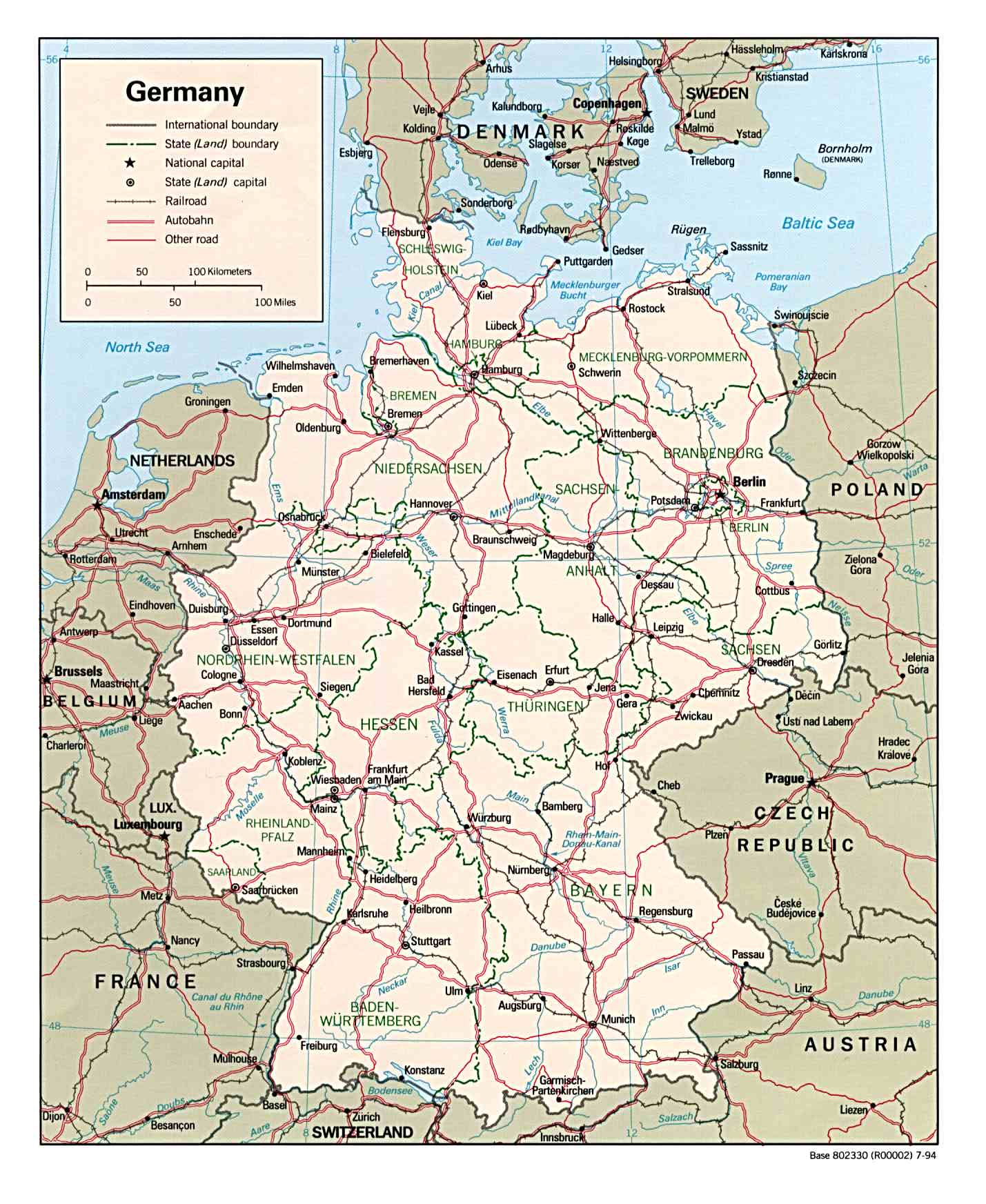
reference map Loading Image...
so the latest try here below represents quite a culmination
even if 6 of the 15 are wetpoints viewed at a considerable distance & 1 of
the 9 purported markers is questionable
1 bbmvni in elbe just south of domitz & centered in following photo
http://www.panoramio.com/photo/56201800
[image: bei Dömitz]
2 bbnist in elbe just east of schnackenburg & at or just beyond far left of
following photo http://www.panoramio.com/photo/71147347
[image: Nachmittag an der Elbe]
3 bbsnst just east of dautzschen in annaburger heide &
purportedly pictured here http://www.panoramio.com/photo/41280738
[image: Dreiländereck in der Annaburger Heide]
4 bwbyhe just east of hesselbach http://www.panoramio.com/photo/71101408
[image: Dreiländereck, Hessen, Bayern, Baden-Württemberg]
5 bwherp in rhein just north of mannheim & centered in following photo
http://www.panoramio.com/photo/34440518
[image: Rhein mit Blick Richtung Mannheim]
6 byheth just east of seiferts http://www.panoramio.com/photo/81597223
[image: Das E c h t e Dreiländereck : Hessen-Bayern-Thüringen - 1]
7 bysnth just west of grobau http://www.panoramio.com/photo/2263329
[image: Der Drei Freistaatenstein an dem Dreiländereck Thüringen, Sachsen
und Bayern]
8 heninw just north of karlshafen http://www.panoramio.com/photo/89925192
[image: Dreiländereck...]
9 henith
https://plus.google.com/photos/110664844632908712547/albums/5656360455904852881?banner=pwa
[image: Photo]
10 henwrp just east of weissenberg
http://www.panoramio.com/photo/52030832#comment
[image: Borderstone - 3 states]
11 hhnishe in elbe just north of stove & centered in following photo
http://www.panoramio.com/photo/88523069
[image: Schleusenkanal mündung zur Elbe]
12 hhnishw in elbe just south of wedel & at far left of following photo
http://www.panoramio.com/photo/48014373
[image: Ex-Schnalles Hafen Panorama]
13 mvnish in elbe just east of sassendorf & centered in following photo
http://www.panoramio.com/photo/12697246
[image: Elbe bei Lauenburg]
14 nistth just west of rothesuette
http://www.landschaftsfotos.eu/name/einzelbild/number/6690/kategorie/Deutschland~Sachsen-Anhalt~Harz.html
[image: Der Drei-Länder-Stein am Jägerfleck. Wo heute Niedersachsen,
Sachsen-Anhalt und Thüringen]
15 snstth just east of langendorf http://www.panoramio.com/photo/67819039
[image: der Dreiherrnstein K.S. (Sachsen), K.P. (Sa.-Anh.) und H.A.
(Thüringen)]
key to digraphs http://www.statoids.com/ude.html
reference map Loading Image...